British Antarctic Survey has launched an AI‑driven iceberg tracker that follows each iceberg from calving to melt, automatically assigning IDs and rebuilding family trees when they break apart. This live dataset lets scientists plug precise melt‑water locations into climate models and gives ship captains clearer forecasts of hazardous ice. You’ll see faster, more accurate climate predictions and safer polar routes.
How the AI Iceberg Tracker Works
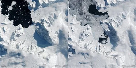
The system ingests high‑resolution satellite imagery and uses deep‑learning algorithms to detect the geometric outlines of every iceberg. Each feature receives a unique identifier, allowing the software to monitor drift paths across the ocean.
Unique ID Assignment and Fragment Linking
When a parent iceberg fractures, the AI reassembles the “family tree” by matching child fragments to their source. This digital jigsaw puzzle creates a continuous record of iceberg lifecycles without manual tagging.
Impacts on Climate Modeling
Accurate melt‑water location data fills a long‑standing gap in ocean‑circulation models. By feeding the tracker’s catalogue into the NEMO component of the UK Earth System Model, researchers can refine salinity fields and improve sea‑level rise projections.
Freshwater Input Accuracy
Scientists now have a searchable database that quantifies how much fresh water each fragment releases, reducing uncertainty in melt‑rate estimates and tightening regional climate forecasts.
Benefits for Polar Navigation
Beyond research, the tracker offers practical tools for vessels navigating icy waters. Real‑time alerts highlight newly formed fragments and predict their drift, helping captains avoid hazardous zones.
Real‑time Alerts for Captains
Ship operators receive concise warnings that can shave days off route planning and boost safety margins. If you’re steering through the Southern Ocean, these insights give you a clearer picture of where dangerous ice is coming from.
Future Expansion and Research
- Integrate the AI pipeline into BAS’s operational monitoring system.
- Extend coverage to the entire Southern Ocean.
- Collaborate with climate institutes to embed iceberg data into global forecasting frameworks.
- Explore additional applications such as autonomous vessel routing and marine ecosystem monitoring.
By turning elusive iceberg fragments into actionable data, the British Antarctic Survey’s AI tracker is reshaping how we understand and respond to a warming planet.